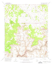
1962 Map of Tuckup Canyon
USGS Topo · Published 1974About this map
The Kanab Plateau dominates this mid-century landscape, dropping precipitously into the depths of Tuckup Canyon and the Colorado River corridor. This remote territory, documented during a 1962 field check, marks a significant convergence of federal and tribal lands, including the Grand Canyon National Monument, the Hualapai Indian Reservation, and the Kaibab National Forest. Water sources are sparse but critical, noted by a network of ranching and wildlife improvements like School Section Tank, June Heaton Tank, and Merle Findlay Tank. The map reveals the intricate geology of the inner canyon, featuring landmarks such as The Dome and The Cork. These named features, along with isolated outposts like Schmutz Spring and Cottonwood Spring, illustrate the survival requirements for navigating this stretch of the Colorado before modern infrastructure changed the accessibility of the North Rim.
Find a feature on this map
57 named features on this map. Tap any name to fly to it.
Don’t see what you’re looking for? This feature index may not catch every label — zoom into the map to look around manually.
Map Details
Editions of this 1962 Tuckup Canyon Map
2 editions found

Other maps of this area

1886 · Mt. Trumbull
USGS Topo · 1:250,000

1886 · Kaibab
USGS Topo · 1:250,000

1892 · Mt. Trumbull
USGS Topo · 1:250,000

1953 · Grand Canyon
USGS Topo · 1:250,000

1954 · Heaton Knolls SE
USGS Topo · 1:24,000

1954 · Heaton Knolls
USGS Topo · 1:62,500

1957 · Grand Canyon
USGS Topo · 1:250,000

1957 · Jumpup Canyon
USGS Topo · 1:62,500

1958 · Grand Canyon
USGS Topo · 1:250,000

1960 · Grand Canyon
USGS Topo · 1:250,000