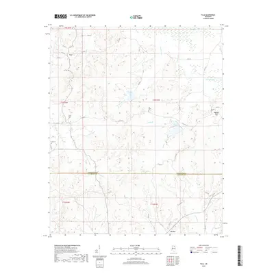
2018 Map of Tula
USGS Topo · Published 2018About this map
Tula and the surrounding rural communities of Spring Hill and Sarepta define the landscape of the north-central Mississippi hill country. Situated along the border of Lafayette and Calhoun Counties, the area is characterized by a network of creeks like Toccopola Cr, Muckaloon Cr, and Lucknuck Cr that feed into the Yocona River. For those researching local family history, several small burial grounds are documented, including Tula Cem, Webb Cem, and Old Dallas Cem. The terrain is punctuated by small bodies of water such as Russell Lake and Coon Cr Lake, illustrating the post-war land management patterns of the region. The road network, consisting primarily of county routes like Co RD 444 and Co RD 167, connects these scattered settlements across the undulating topography of the Potlockney Cr and Coupen Cr drainage basins.
Find a feature on this map
52 named features on this map. Tap any name to fly to it.
Don’t see what you’re looking for? This feature index may not catch every label — zoom into the map to look around manually.
Map Details
Editions of this 2018 Tula Map
This is the sole edition of this map. No revisions or reprints were ever made.
Other maps of this area

1942 · Denmark
USGS Topo · 1:62,500

1943 · Denmark
USGS Topo · 1:62,500

1949 · New Albany
USGS Topo · 1:62,500

1951 · New Albany
USGS Topo · 1:62,500

1956 · Tupelo
USGS Topo · 1:250,000

1958 · Tupelo
USGS Topo · 1:250,000

1972 · Paris
USGS Topo · 1:24,000

1972 · Robbs
USGS Topo · 1:24,000
1972 · Banner
USGS Topo · 1:24,000

1972 · Randolph
USGS Topo · 1:24,000