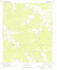
1972 Map of Tula
USGS Topo · Published 1975About this map
The Yocona River and its numerous tributaries dominate this early 1970s landscape along the boundary of Lafayette and Calhoun Counties. The settlement of Tula serves as a primary landmark in the north, while Sarepta anchors the southern portion of the sheet. The terrain is defined by a dense network of watercourses including Sandy Creek, Potlockney Creek, and Lucknuck Creek, which shaped the placement of local homesteads and travel routes.
Find a feature on this map
26 named features on this map. Tap any name to fly to it.
Don’t see what you’re looking for? This feature index may not catch every label — zoom into the map to look around manually.
Map Details
Editions of this 1972 Tula Map
This is the sole edition of this map. No revisions or reprints were ever made.
Other maps of this area

1942 · Denmark
USGS Topo · 1:62,500

1943 · Denmark
USGS Topo · 1:62,500

1949 · New Albany
USGS Topo · 1:62,500

1951 · New Albany
USGS Topo · 1:62,500

1956 · Tupelo
USGS Topo · 1:250,000

1958 · Tupelo
USGS Topo · 1:250,000

1972 · Paris
USGS Topo · 1:24,000

1972 · Robbs
USGS Topo · 1:24,000
1972 · Banner
USGS Topo · 1:24,000

1972 · Randolph
USGS Topo · 1:24,000