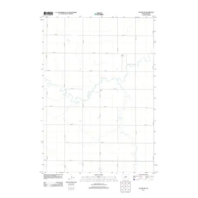
2012 Map of Tulare NW
USGS Topo · Published 2012About this map
Turtle Creek and Wolf Creek define the drainage of this prairie landscape in Spink County, winding through the regular grid of section-line roads like 375th Ave and 187th St. The map highlights the localized history of rural Lake Township through its isolated burial grounds, specifically Saint Johns Cemetery in the northeast and Buffalo Cemetery situated near a bend in the creek. These features, along with the numerous unnamed wetland depressions scattered across the quadrants, illustrate the enduring agricultural character of the South Dakota plains into the early 21st century. The network of numbered avenues and streets reflects the systematic land division that has organized this region since settlement, providing clear reference points for modern-day land use and genealogical research.
Find a feature on this map
21 named features on this map. Tap any name to fly to it.
Don’t see what you’re looking for? This feature index may not catch every label — zoom into the map to look around manually.
Map Details
Editions of this 2012 Tulare NW Map
This is the sole edition of this map. No revisions or reprints were ever made.
Other maps of this area

1899 · Redfield
USGS Topo · 1:125,000

1953 · Huron
USGS Topo · 1:250,000

1954 · Huron
USGS Topo · 1:250,000

1966 · Burdette
USGS Topo · 1:24,000

1966 · Redfield South
USGS Topo · 1:24,000
1966 · Rockham SE
USGS Topo · 1:24,000

1966 · Redfield SW
USGS Topo · 1:24,000

1967 · Tulare NW
USGS Topo · 1:24,000

1967 · Tulare SE
USGS Topo · 1:24,000
1967 · Miller SE
USGS Topo · 1:24,000