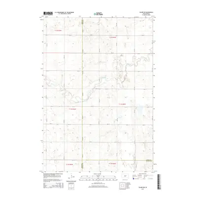
2015 Map of Tulare NW
USGS Topo · Published 2015About this map
Turtle Creek and Wolf Creek meander through this rural section of Spink County, where the plains are organized by a strict cardinal grid of section lines and gravel roads. The landscape reflects the established agricultural patterns of the early 21st century, punctuated by local landmarks of genealogical interest such as Saint Johns Cem and Buffalo Cem. This area sits at a geographic crossroads of several South Dakota counties, with the western boundary marking the line for Hand County and the southern edge meeting Beadle County. The map provides a precise look at the drainage patterns of Turtle Cr as it winds across t114n r65w and t115n r65w, revealing the subtle topography that defines this farming region.
Find a feature on this map
30 named features on this map. Tap any name to fly to it.
Don’t see what you’re looking for? This feature index may not catch every label — zoom into the map to look around manually.
Map Details
Editions of this 2015 Tulare NW Map
This is the sole edition of this map. No revisions or reprints were ever made.
Other maps of this area

1899 · Redfield
USGS Topo · 1:125,000

1953 · Huron
USGS Topo · 1:250,000

1954 · Huron
USGS Topo · 1:250,000

1966 · Burdette
USGS Topo · 1:24,000

1966 · Redfield South
USGS Topo · 1:24,000
1966 · Rockham SE
USGS Topo · 1:24,000

1966 · Redfield SW
USGS Topo · 1:24,000

1967 · Tulare NW
USGS Topo · 1:24,000

1967 · Tulare SE
USGS Topo · 1:24,000
1967 · Miller SE
USGS Topo · 1:24,000