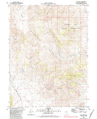
1980 Map of Tule Peak
USGS Topo · Published 1984About this map
The Virginia Mountains dominate this 1980 survey, characterized by the high elevations of Tule Peak and the expansive Painted Hills. This arid landscape is defined by its water sources, with isolated points like Mud Spring, Cove Spring, and Pridmore Spring serving as vital landmarks in the high desert. To the east, the boundary of the Pyramid Lake Indian Reservation encompasses a significant portion of the terrain, where Hardscrabble Creek flows toward the lake basin.
Find a feature on this map
25 named features on this map. Tap any name to fly to it.
Don’t see what you’re looking for? This feature index may not catch every label — zoom into the map to look around manually.
Map Details
Editions of this 1980 Tule Peak Map
2 editions found
Other maps of this area

1886 · Granite Range
USGS Topo · 1:250,000

1891 · Reno
USGS Topo · 1:125,000

1893 · Reno
USGS Topo · 1:125,000

1894 · Granite Range
USGS Topo · 1:250,000

1955 · Lovelock
USGS Topo · 1:250,000

1957 · Sutcliffe
USGS Topo · 1:62,500

1957 · Dogskin Mountain
USGS Topo · 1:62,500

1957 · Reno
USGS Topo · 1:250,000

1959 · Lovelock
USGS Topo · 1:250,000

1959 · Reno
USGS Topo · 1:250,000