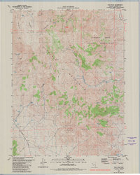
1980 Map of Tule Peak
USGS Topo · Published 1980About this map
Pyramid Lake Indian Reservation lands dominate the eastern portion of this high-desert Nevada terrain, where the slopes of the Virginia Mountains rise toward the summit of Tule Peak. The map reveals a landscape defined by scarce water resources and long-distance transit, featuring numerous small water sources like Mud Spring, Cove Springs, and Water Hole Canyon. These springs likely served as critical waypoints for early ranching and travel in this arid region of Washoe County.
Find a feature on this map
22 named features on this map. Tap any name to fly to it.
Don’t see what you’re looking for? This feature index may not catch every label — zoom into the map to look around manually.
Map Details
Editions of this 1980 Tule Peak Map
2 editions found
Other maps of this area

1886 · Granite Range
USGS Topo · 1:250,000

1891 · Reno
USGS Topo · 1:125,000

1893 · Reno
USGS Topo · 1:125,000

1894 · Granite Range
USGS Topo · 1:250,000

1955 · Lovelock
USGS Topo · 1:250,000

1957 · Sutcliffe
USGS Topo · 1:62,500

1957 · Dogskin Mountain
USGS Topo · 1:62,500

1957 · Reno
USGS Topo · 1:250,000

1959 · Lovelock
USGS Topo · 1:250,000

1959 · Reno
USGS Topo · 1:250,000