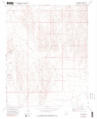
1973 Map of Tule Spring
USGS Topo · Published 1990About this map
Tule Spring and Abe Spring provide critical water points in this arid pocket of Lincoln County, where the topography transitions from the open Tule Desert into the broken terrain of the Tule Spring Hills. This 1970s survey captures a landscape defined by isolation, where human activity is limited to a few scattered signs of exploration and passage. The presence of a Prospect in the southern hills suggests mineral interest typical of the region, while named terrain features like Steer Flat, Jumbled Mtn, and the curiously named The Ribbons indicate a landscape well-known to local ranchers and surveyors. The network of Jeep Trails and unnamed Trails weaving through Sand Hollow and across the desert floor reveals the primary routes for navigating this remote territory before modern development or major cultural changes occurred.
Find a feature on this map
15 named features on this map. Tap any name to fly to it.
Don’t see what you’re looking for? This feature index may not catch every label — zoom into the map to look around manually.
Map Details
Editions of this 1973 Tule Spring Map
3 editions found
Other maps of this area

1885 · Pioche
USGS Topo · 1:250,000

1886 · Saint Thomas
USGS Topo · 1:250,000

1886 · Pioche
USGS Topo · 1:250,000

1893 · Saint Thomas
USGS Topo · 1:250,000

1954 · Caliente
USGS Topo · 1:250,000

1954 · Las Vegas
USGS Topo · 1:250,000

1957 · Las Vegas
USGS Topo · 1:250,000

1957 · Mesquite
USGS Topo · 1:62,500

1959 · Caliente
USGS Topo · 1:250,000

1959 · Las Vegas
USGS Topo · 1:250,000