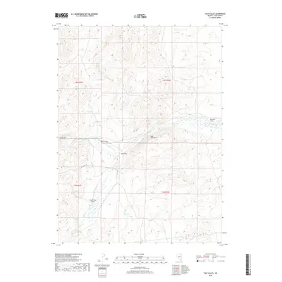
2018 Map of Tule Valley
USGS Topo · Published 2018About this map
The N Fork Humboldt River carves a critical path through this high-elevation corner of Elko County, where seasonal water sources dictate the landscape's utility. Significant springs such as Water Canyon Spring, Mud Springs, and Green Spring appear as vital points of interest for those tracing the history of open-range grazing and early ranching infrastructure. The presence of Keddy Ranch Rd provides a rare modern trace through the basin, connecting the sprawling Tule Valley with the surrounding heights of Lost Wallet Rim. To the north, the terrain transitions into the Willming Valley, while narrow geographical features like Devils Gap and Water Canyon suggest the natural bottlenecks and corridors used by travelers and livestock moving through this remote Nevada territory.
Find a feature on this map
18 named features on this map. Tap any name to fly to it.
Don’t see what you’re looking for? This feature index may not catch every label — zoom into the map to look around manually.
Map Details
Editions of this 2018 Tule Valley Map
This is the sole edition of this map. No revisions or reprints were ever made.
Other maps of this area

1955 · Wells
USGS Topo · 1:250,000

1958 · Wells
USGS Topo · 1:250,000

1961 · Wells
USGS Topo · 1:250,000

1971 · Double Mtn
USGS Topo · 1:24,000

1971 · Devils Armchair
USGS Topo · 1:24,000
1971 · Coal Mine Basin
USGS Topo · 1:24,000

1971 · North Fork
USGS Topo · 1:24,000
1971 · Wieland Flat
USGS Topo · 1:24,000

1971 · Double Mtn SE
USGS Topo · 1:24,000
1971 · Mahala Creek East
USGS Topo · 1:24,000