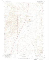
1971 Map of Wieland Flat
USGS Topo · Published 1974About this map
Wieland Flat dominates this high-elevation basin in Elko County, where the 1971 landscape is defined by its seasonal water sources and rugged resource extraction. Several drainages including Pie Creek, Dorsey Creek, and Willow Creek carve through the terrain, sustained by scattered perennial points like China Spring and the aptly named Coal Mine Creek to the northeast. The presence of a prospect and multiple borrow pits suggests active or historic earth-moving operations, likely supporting the network of jeep trails that provide the only passage across these slopes.
Find a feature on this map
18 named features on this map. Tap any name to fly to it.
Don’t see what you’re looking for? This feature index may not catch every label — zoom into the map to look around manually.
Map Details
Editions of this 1971 Wieland Flat Map
2 editions found
Other maps of this area

1955 · Wells
USGS Topo · 1:250,000

1958 · Wells
USGS Topo · 1:250,000

1958 · Singletree Creek
USGS Topo · 1:24,000

1961 · Wells
USGS Topo · 1:250,000

1971 · Mahala Creek West
USGS Topo · 1:24,000
1971 · Coal Mine Basin
USGS Topo · 1:24,000
1971 · Dinner Station
USGS Topo · 1:24,000
1971 · The Buttes
USGS Topo · 1:24,000
1971 · Reed Station
USGS Topo · 1:24,000
1971 · Mahala Creek East
USGS Topo · 1:24,000