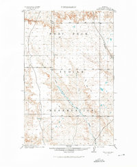
1915 Map of Tule Valley
USGS Topo · Published 1976About this map
Fort Peck Indian Reservation dominates this 1915 landscape, surveyed by the General Land Office just before the first World War. The terrain is defined by the broad drainage of the Tule Valley, where the intermittent flow of Tule Creek and its North Fork carve through the plains. The map reflects a period of transition for this part of Montana, showing the early township and range grid system overlaid across the ancestral lands of the Assiniboine and Sioux. Water is the primary marker of life and geography here, from the isolated Spring in the north to the path of Boxelder Creek winding along the eastern boundary. The sparse settlement pattern and lack of major road infrastructure during the 1909-1910 survey period highlight the area's isolation prior to later development.
Find a feature on this map
14 named features on this map. Tap any name to fly to it.
Don’t see what you’re looking for? This feature index may not catch every label — zoom into the map to look around manually.
Map Details
Editions of this 1915 Tule Valley Map
2 editions found
Other maps of this area

1910 · Todd Lakes
USGS Topo · 1:62,500

1910 · Cuskers
USGS Topo · 1:62,500

1912 · Chelsea
USGS Topo · 1:62,500

1915 · Tule Valley
USGS Topo · 1:62,500

1915 · Oswego
USGS Topo · 1:62,500

1915 · Cuskers
USGS Topo · 1:62,500

1915 · Todd Lakes
USGS Topo · 1:62,500

1916 · Wolf Point
USGS Topo · 1:62,500

1954 · Wolf Point
USGS Topo · 1:250,000

1958 · Wolf Point
USGS Topo · 1:250,000