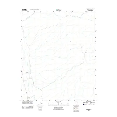
2011 Map of Tule Wash
USGS Topo · Published 2011About this map
Big Sandy River defines the western edge of this arid landscape in Mohave County, where the terrain is carved by an intricate network of seasonal drainage systems. The topography is dominated by several significant washes, including Tule Wash, Big Wash, and Burro Wash, which move water across the desert floor toward the river. To the east, the landscape rises into distinct natural features such as Bull Canyon, while northern drainages like Pearson Falls Wash lead toward Orhando Spring. Human infrastructure is sparse, represented primarily by the north-south corridor of CO Hwy 159 and a handful of rugged tracks. This map provides a clear record of the area's physical geography, from the deep cuts of Gunsight Canyon and Tompkins Canyon to the wide alluvial paths of the primary washes.
Find a feature on this map
10 named features on this map. Tap any name to fly to it.
Don’t see what you’re looking for? This feature index may not catch every label — zoom into the map to look around manually.
Map Details
Editions of this 2011 Tule Wash Map
This is the sole edition of this map. No revisions or reprints were ever made.
Other maps of this area

1923 · Signal
USGS Topo · 1:250,000

1942 · Signal
USGS Topo · 1:250,000

1950 · Prescott
USGS Topo · 1:250,000

1954 · Prescott
USGS Topo · 1:250,000

1958 · Prescott
USGS Topo · 1:250,000

1959 · Prescott
USGS Topo · 1:250,000

1960 · Prescott
USGS Topo · 1:250,000

1965 · Prescott
USGS Topo · 1:250,000
1967 · Gunsight Canyon
USGS Topo · 1:24,000
1967 · Pilgrim Wash
USGS Topo · 1:24,000