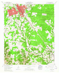
1962 Map of Tullahoma
USGS Topo · Published 1965About this map
Tullahoma serves as a major hub for aviation and military engineering in the early 1960s, dominated by the massive Arnold Engineering Development Center (U S Air Force) and the Former Camp Forrest Military Reservation. The town itself exhibits rapid post-war residential expansion through neighborhoods like Pineview Heights, Bel-Aire, and Westside Heights. This growth is anchored by civil infrastructure including William Northern Field and the Tennessee Vocational School for Girls.
Find a feature on this map
77 named features on this map. Tap any name to fly to it.
Don’t see what you’re looking for? This feature index may not catch every label — zoom into the map to look around manually.
Map Details
Editions of this 1962 Tullahoma Map
This is the sole edition of this map. No revisions or reprints were ever made.
Other maps of this area

1928 · Decherd
USGS Topo · 1:62,500

1936 · Ovoca
USGS Topo · 1:24,000

1936 · Manchester
USGS Topo · 1:24,000

1936 · Cumberland Springs
USGS Topo · 1:24,000

1936 · Winchester
USGS Topo · 1:24,000

1936 · Belvidere
USGS Topo · 1:24,000

1936 · Camp Peay
USGS Topo · 1:24,000

1936 · Capitol Hill
USGS Topo · 1:24,000

1936 · Normandy
USGS Topo · 1:24,000

1936 · Lois
USGS Topo · 1:24,000