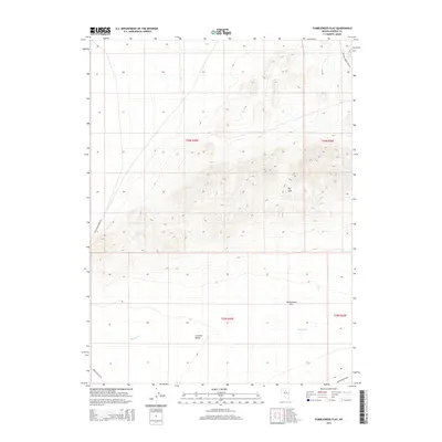
2014 Map of Tumbleweed Flat
USGS Topo · Published 2014About this map
Crescent Valley dominates the southern reaches of this landscape, a wide basin floor that contrasts sharply with the elevated terrain of the Dry Hills to the northeast. This 2014 survey captures a sparsely settled portion of Eureka County, defined by the drainage patterns of Neil Cr and Thomas Cr as they descend from higher ground toward the valley floor. The map illustrates a network of remote access routes that trace the contours of the Great Basin, including Willow Corral Pass Rd in the north and the junction of Dean Dann Spa Rd and Dann Frenchie Rd in the southeast. Named for the iconic western tumbleweed, Tumbleweed Flat occupies the central transition between the foothills and the playa, providing a detailed record of the township and range divisions within T30N and T29N.
Find a feature on this map
13 named features on this map. Tap any name to fly to it.
Don’t see what you’re looking for? This feature index may not catch every label — zoom into the map to look around manually.
Map Details
Editions of this 2014 Tumbleweed Flat Map
This is the sole edition of this map. No revisions or reprints were ever made.
Other maps of this area

1949 · Crescent Valley
USGS Topo · 1:62,500

1950 · Crescent Valley
USGS Topo · 1:62,500

1955 · Winnemucca
USGS Topo · 1:250,000

1957 · Frenchie Creek
USGS Topo · 1:62,500

1957 · Dunphy
USGS Topo · 1:62,500

1957 · Beowawe
USGS Topo · 1:62,500

1958 · Winnemucca
USGS Topo · 1:250,000

1962 · Winnemucca
USGS Topo · 1:250,000
1985 · Thatcher Spring
USGS Topo · 1:24,000
1985 · Hand-Me-Down Creek
USGS Topo · 1:24,000