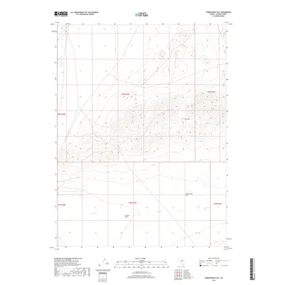
2018 Map of Tumbleweed Flat
USGS Topo · Published 2018About this map
Crescent Valley dominates the southern reaches of this 2018 survey, where the low-lying terrain meets the southern slopes of the Dry Hills. The topographical transition defines the regional hydrology, as seasonal drainages like Thomas Cr and Neil Cr flow toward the lower basin floor. In the eastern portion of the valley, the small settlement of Tumbleweed Flat sits at a junction of local roads, reflecting the sparse, wide-open character of this part of Nevada. The landscape is primarily defined by its drainage patterns and the contrast between the flat valley floor and the surrounding hills, which rise several hundred feet above the basin. This USGS survey documents the land use and physical geography of the area as it existed in the late 2010s.
Find a feature on this map
11 named features on this map. Tap any name to fly to it.
Don’t see what you’re looking for? This feature index may not catch every label — zoom into the map to look around manually.
Map Details
Editions of this 2018 Tumbleweed Flat Map
This is the sole edition of this map. No revisions or reprints were ever made.
Other maps of this area

1949 · Crescent Valley
USGS Topo · 1:62,500

1950 · Crescent Valley
USGS Topo · 1:62,500

1955 · Winnemucca
USGS Topo · 1:250,000

1957 · Frenchie Creek
USGS Topo · 1:62,500

1957 · Dunphy
USGS Topo · 1:62,500

1957 · Beowawe
USGS Topo · 1:62,500

1958 · Winnemucca
USGS Topo · 1:250,000

1962 · Winnemucca
USGS Topo · 1:250,000
1985 · Thatcher Spring
USGS Topo · 1:24,000
1985 · Hand-Me-Down Creek
USGS Topo · 1:24,000