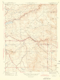
1944 Map of Tungsten
USGS Topo · Published 1944About this map
Roosevelt National Forest spans this 1940s landscape, where the rugged topography of the Front Range dictated a pattern of narrow mountain settlements and resource extraction. The Denver and Salt Lake railroad winds through the canyon of South Boulder Creek, providing a vital transit corridor connecting Rollinsville and Pine Cliff Pineliffe PO. This era shows the region as a hub for both industrial mining and early mountain recreation, evidenced by the Manchester Mine and Kekionga Mine alongside seasonal sites like Camp Shoshoni and the Lincoln Hills development.
Find a feature on this map
54 named features on this map. Tap any name to fly to it.
Don’t see what you’re looking for? This feature index may not catch every label — zoom into the map to look around manually.
Map Details
Editions of this 1944 Tungsten Map
This is the sole edition of this map. No revisions or reprints were ever made.
Other maps of this area

1899 · West Denver
USGS Topo · 1:125,000

1902 · Boulder
USGS Topo · 1:62,500

1904 · Boulder
USGS Topo · 1:62,500

1905 · Central City
USGS Topo · 1:62,500

1906 · Blackhawk
USGS Topo · 1:62,500

1910 · Central City
USGS Topo · 1:62,500

1912 · Central City
USGS Topo · 1:62,500

1915 · Longs Peak
USGS Topo · 1:125,000

1919 · Rocky Mountain National Park
USGS Topo · 1:125,000

1942 · Eldorado Springs
USGS Topo · 1:24,000