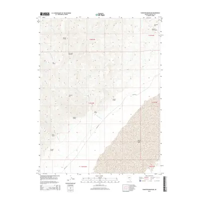
2014 Map of Tungsten Mountain
USGS Topo · Published 2014About this map
Tungsten Mtn stands as a prominent landmark within the Clan Alpine Mountains, a landscape defined by deep drainages and isolated water sources. This 2014 survey captures the high-desert character of central Nevada, where ephemeral flows like Willow Canyon Cr and Bernice Cr descend through steep-walled features such as Bernice Canyon and Rocky Canyon. The presence of Eagle Springs, Bob Spring, and Smooth Canyon Spring suggests the critical importance of reliable water points in this arid environment. To the east, the topography yields to the broad expanse of the Edwards Creek Valley, accessed via Shoshone Pass. The map traces Alpine Rd W, the primary corridor through this sparsely settled region, connecting the rugged highlands of Stone Canyon and Augusta Canyon with the valley floor.
Find a feature on this map
26 named features on this map. Tap any name to fly to it.
Don’t see what you’re looking for? This feature index may not catch every label — zoom into the map to look around manually.
Map Details
Editions of this 2014 Tungsten Mountain Map
This is the sole edition of this map. No revisions or reprints were ever made.
Other maps of this area

1955 · Millett
USGS Topo · 1:250,000

1959 · Millett
USGS Topo · 1:250,000

1966 · Clan Alpine Ranch
USGS Topo · 1:62,500

1966 · Humboldt Salt Marsh
USGS Topo · 1:62,500

1966 · Shoshone Meadows
USGS Topo · 1:62,500

1966 · Edwards Creek Valley
USGS Topo · 1:62,500

1983 · Edwards Creek Valley
USGS Topo · 1:100,000

1990 · Byers Ranch
USGS Topo · 1:24,000
1990 · Bernice Canyon
USGS Topo · 1:24,000
1990 · Byers Canyon
USGS Topo · 1:24,000