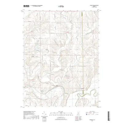
2019 Map of Tunnelton
USGS Topo · Published 2019About this map
The East Fork White River carves a deep, winding path through the limestone-dominated landscape of Lawrence County, Indiana, creating the dramatic narrow ridge known as the Devils Backbone. This 2019 survey documents the river-oriented geography of small rural settlements including Tunnelton and Fort Ritner, both situated along the primary rail line following the river valley. The topography is defined by sharp elevation changes, particularly at Tunnel Hill and the steep Hemlock Bluff further east.
Find a feature on this map
92 named features on this map. Tap any name to fly to it.
Don’t see what you’re looking for? This feature index may not catch every label — zoom into the map to look around manually.
Map Details
Editions of this 2019 Tunnelton Map
This is the sole edition of this map. No revisions or reprints were ever made.
Other maps of this area

1934 · Bedford
USGS Topo · 1:48,000

1937 · Bedford
USGS Topo · 1:62,500

1950 · Mitchell
USGS Topo · 1:24,000

1951 · Smedley
USGS Topo · 1:24,000

1956 · Vincennes
USGS Topo · 1:250,000

1957 · Vincennes
USGS Topo · 1:250,000

1957 · Campbellsburg
USGS Topo · 1:24,000

1958 · Vincennes
USGS Topo · 1:250,000
1958 · Bartlettsville
USGS Topo · 1:24,000
1958 · Norman
USGS Topo · 1:24,000