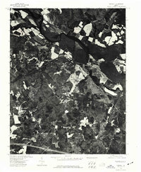
1974 Map of Tunstall
USGS Topo · Published 1977About this map
Tunstall is the primary focus of this 1974 orthophotoquad, which provides a detailed aerial view of the New Kent County landscape. Unlike traditional line-drawn maps, this photo-based survey preserves the physical textures of the land as it appeared in the mid-1970s. The image reveals a patchwork of agricultural fields and dense woodlands, punctuated by the winding course of the Pamunkey River at the top of the sheet and various tributaries cutting through the coastal plain. The distribution of cleared land and timber suggests a landscape still deeply rooted in traditional Virginia farming practices, with visible property lines and farmstead clearings providing a direct link to the region's rural history and development patterns during the late twentieth century.
Find a feature on this map
1 named feature on this map. Tap any name to fly to it.
Don’t see what you’re looking for? This feature index may not catch every label — zoom into the map to look around manually.
Map Details
Editions of this 1974 Tunstall Map
This is the sole edition of this map. No revisions or reprints were ever made.
Other maps of this area

1917 · Toano
USGS Topo · 1:62,500

1918 · Charles City
USGS Topo · 1:62,500

1918 · Toano
USGS Topo · 1:62,500

1919 · New Kent
USGS Topo · 1:62,500

1920 · King William
USGS Topo · 1:62,500

1943 · Richmond
USGS Topo · 1:250,000
1949 · King William
USGS Topo · 1:24,000
1949 · Quinton
USGS Topo · 1:24,000
1949 · King And Queen
USGS Topo · 1:24,000

1949 · Tunstall
USGS Topo · 1:24,000