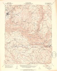
1948 Map of Tuolumne
USGS Topo · Published 1953About this map
Tuolumne and the surrounding Sierra foothills define this mid-century landscape, where mining and timber interests shaped the early 20th-century development of the Stanislaus National Forest. The map captures a critical era of infrastructure, notably the path of the Hetch Hetchy Aqueduct and the presence of the Arastraville Canal. Local industry is evidenced by numerous workings such as the Ophir Mine, Aqua Caliente Mine, and Jigger Bill Mine, while community life centers around Groveland, Arastraville, and Second Garrotte. Genealogists will find valuable markers in the Cherokee Cem and Groveland Cem, alongside family-named locations like Murphy Ranch and Matson Ranch. The terrain is marked by significant hydrological features including the North Fork Tuolumne River and Clavey River, which descend through Paper Cabin Ridge and Duckwall Ridge toward the Merced River at the southern boundary.
Find a feature on this map
75 named features on this map. Tap any name to fly to it.
Don’t see what you’re looking for? This feature index may not catch every label — zoom into the map to look around manually.
Map Details
Editions of this 1948 Tuolumne Map
4 editions found
Other maps of this area

1891 · Big Trees
USGS Topo · 1:125,000

1893 · Sonora
USGS Topo · 1:125,000

1894 · Big Trees
USGS Topo · 1:125,000

1896 · Dardanelles
USGS Topo · 1:125,000

1896 · Sonora
USGS Topo · 1:125,000

1897 · Sonora
USGS Topo · 1:125,000

1897 · Big Trees
USGS Topo · 1:125,000

1897 · Yosemite
USGS Topo · 1:125,000

1898 · Dardanelles
USGS Topo · 1:125,000

1898 · Sonora
USGS Topo · 1:125,000