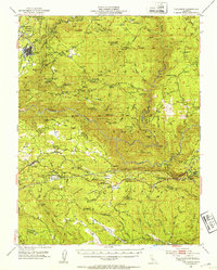
1948 Map of Tuolumne
USGS Topo · Published 1953About this map
Tuolumne and Groveland anchor this survey of the foothills and river canyons, captured just after the mid-century. The landscape is defined by the steep drainage of the Tuolumne River and its major tributaries, including the North Fork Tuolumne River and the Clavey River. Transport and utility infrastructure shape the region, with the Sierra RR serving the timber and mining interests of the north, while the Hetch Hetchy RR and Hetch Hetchy Aqueduct trace the path of urban water development through the southern terrain.
Find a feature on this map
101 named features on this map. Tap any name to fly to it.
Don’t see what you’re looking for? This feature index may not catch every label — zoom into the map to look around manually.
Map Details
Editions of this 1948 Tuolumne Map
4 editions found
Other maps of this area

1891 · Big Trees
USGS Topo · 1:125,000

1893 · Sonora
USGS Topo · 1:125,000

1894 · Big Trees
USGS Topo · 1:125,000

1896 · Dardanelles
USGS Topo · 1:125,000

1896 · Sonora
USGS Topo · 1:125,000

1897 · Sonora
USGS Topo · 1:125,000

1897 · Big Trees
USGS Topo · 1:125,000

1897 · Yosemite
USGS Topo · 1:125,000

1898 · Dardanelles
USGS Topo · 1:125,000

1898 · Sonora
USGS Topo · 1:125,000