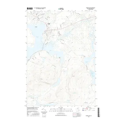
2016 Map of Tupper Lake
USGS Topo · Published 2016About this map
Tupper Lake and the nearby settlement of Moody serve as the focal points of this Adirondack landscape, where the Raquette River flows through a complex network of waterways including Raquette Pond and Simon Pond. The village layout is densely detailed, showing the residential and commercial grid from Main St to Demars Blvd, and north toward Little Wolf Pond. A concentration of local history is found at the intersection of Stetson Rd and Hosley Ave, where Lakeview Cem, Beth Joseph Cem, and Saint Alphonsus Cem are located. To the south, the terrain rises sharply toward Mt Morris and Buck Mtn. This area is largely contained within the Adirondack Park Preserve, protecting the vast wetlands and water bodies such as Follensby Pond and Heavens Lake that define the regional geography.
Find a feature on this map
65 named features on this map. Tap any name to fly to it.
Don’t see what you’re looking for? This feature index may not catch every label — zoom into the map to look around manually.
Map Details
Editions of this 2016 Tupper Lake Map
This is the sole edition of this map. No revisions or reprints were ever made.
Other maps of this area

1904 · Long Lake
USGS Topo · 1:62,500

1905 · Saint Regis
USGS Topo · 1:62,500

1907 · Tupper Lake
USGS Topo · 1:62,500

1920 · Childwold
USGS Topo · 1:62,500

1921 · Childwold
USGS Topo · 1:48,000

1922 · Childwold
USGS Topo · 1:62,500

1948 · Ogdensburg
USGS Topo · 1:250,000

1951 · Ogdensburg
USGS Topo · 1:250,000

1953 · Ogdensburg
USGS Topo · 1:250,000

1954 · Tupper Lake
USGS Topo · 1:62,500