
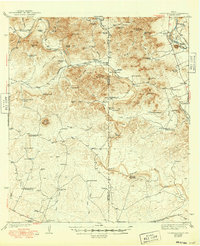
1943 Map of Turkey Mountain
USGS Topo · Published 1943About this map
The West Nueces River carves a winding path through this corner of the Edwards Plateau, where the arid landscape of Kinney and Uvalde counties is defined by a sparse network of ranching outposts. This 1938 survey captures a period when survival in the brush country relied heavily on scattered water sources like Edwards Waterhole and Mustang Waterhole, alongside dozens of mechanical windmills that supported local operations.
Find a feature on this map
63 named features on this map. Tap any name to fly to it.
Don’t see what you’re looking for? This feature index may not catch every label — zoom into the map to look around manually.
Map Details
Editions of this 1943 Turkey Mountain Map
2 editions found
Other maps of this area

1893 · Nueces
USGS Topo · 1:125,000

1896 · Nueces
USGS Topo · 1:125,000

1896 · Brackett
USGS Topo · 1:125,000

1897 · Brackett
USGS Topo · 1:125,000

1898 · Uvalde
USGS Topo · 1:125,000

1899 · Uvalde
USGS Topo · 1:125,000

1938 · Turkey Mountain
USGS Topo · 1:48,000

1944 · Barksdale
USGS Topo · 1:62,500

1944 · Spofford
USGS Topo · 1:62,500

1944 · Brackettville
USGS Topo · 1:62,500