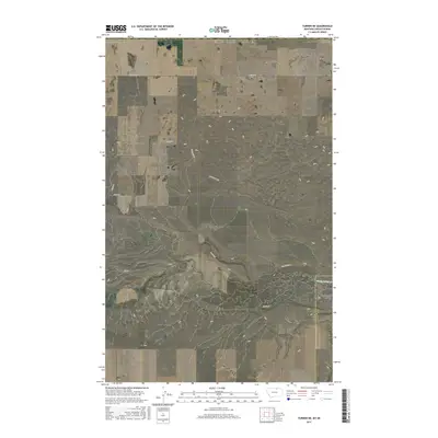
2017 Map of Turner NE
USGS Topo · Published 2017About this map
Woody Island Cr flows through the southeastern corner of this northern Montana landscape, carved by the Woody Island Coulee along the border of Blaine and Phillips Counties. This high-plains terrain is defined by its vast sections and a sparse network of dirt and gravel paths that serve the region's isolated agricultural interests. Named thoroughfares like Hutton Rd, Desaye Rd, and the curiously named Cow Shack Blvd cross the open range, while Pig Spring provides a rare landmark in the center of the sheet. The northern edge of the map follows the international boundary where the United States meets Canada, a quiet frontier marked only by section lines and the occasional path like School Bus Rd.
Find a feature on this map
19 named features on this map. Tap any name to fly to it.
Don’t see what you’re looking for? This feature index may not catch every label — zoom into the map to look around manually.
Map Details
Editions of this 2017 Turner NE Map
This is the sole edition of this map. No revisions or reprints were ever made.
Other maps of this area

1920 · Avery
USGS Topo · 1:125,000

1953 · Havre
USGS Topo · 1:250,000

1957 · Havre
USGS Topo · 1:250,000

1958 · Havre
USGS Topo · 1:250,000

1984 · Chapman
USGS Topo · 1:24,000
1984 · Chapman NW
USGS Topo · 1:24,000

1984 · Turner
USGS Topo · 1:24,000

1984 · Turner NE
USGS Topo · 1:24,000
1984 · Turner NW
USGS Topo · 1:24,000
1984 · Turner SE
USGS Topo · 1:24,000