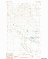
1984 Map of Turner NW
USGS Topo · Published 1984About this map
The Canada United States international border bisects this 1984 survey, marking the northernmost reaches of Blaine Co, Montana. This landscape is defined by the ephemeral drainage systems of the northern plains, where Woody Island Coulee winds across the international boundary line. To the south, the terrain descends toward Buckley Creek, reflecting the sparse and specialized topography of the Saskatchewan Montana frontier. The lack of concentrated settlements or infrastructure on this map highlights the expansive, open character of the high plains during the late 20th century. Local historians and land researchers can trace the specific path of these watercourses as they dictated land use and property boundaries along the 49th parallel, where the rugged natural drainage remains the primary geographic feature.
Find a feature on this map
5 named features on this map. Tap any name to fly to it.
Don’t see what you’re looking for? This feature index may not catch every label — zoom into the map to look around manually.
Map Details
Editions of this 1984 Turner NW Map
This is the sole edition of this map. No revisions or reprints were ever made.
Other maps of this area

1913 · Cherry Ridge
USGS Topo · 1:125,000

1920 · Avery
USGS Topo · 1:125,000

1953 · Havre
USGS Topo · 1:250,000

1957 · Havre
USGS Topo · 1:250,000

1958 · Havre
USGS Topo · 1:250,000

1984 · Hogeland SE
USGS Topo · 1:24,000

1984 · Turner
USGS Topo · 1:24,000

1984 · Turner NE
USGS Topo · 1:24,000
1984 · Mosquito Springs
USGS Topo · 1:24,000
1984 · Turner SE
USGS Topo · 1:24,000