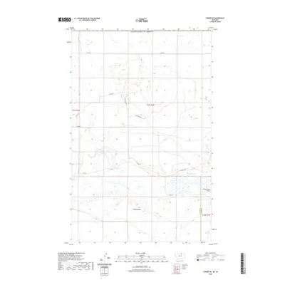
2020 Map of Turner NE
USGS Topo · Published 2020About this map
Woody Island Cr and Woody Island Coulee dominate the southern portion of this high plains landscape along the Blaine Co Phillips Co line. This northern Montana terrain is characterized by a sparse network of roads that reflect the area's agricultural and ranching heritage. Local travel is defined by routes such as Hutton Rd and School Bus Rd, while the whimsically named Cow Shack Blvd and Pig Springs Rd hint at the specific livestock operations that have shaped land use in this corner of the state. The map details the precise township and range boundaries including t37n r26e, providing a clear look at the large-scale grid system used for land management. Pig Spring stands out as a critical water source in a region where such features are infrequent, anchoring the network of surrounding trails and cattle roads like Cowen Rd.
Find a feature on this map
17 named features on this map. Tap any name to fly to it.
Don’t see what you’re looking for? This feature index may not catch every label — zoom into the map to look around manually.
Map Details
Editions of this 2020 Turner NE Map
This is the sole edition of this map. No revisions or reprints were ever made.
Other maps of this area

1920 · Avery
USGS Topo · 1:125,000

1953 · Havre
USGS Topo · 1:250,000

1957 · Havre
USGS Topo · 1:250,000

1958 · Havre
USGS Topo · 1:250,000

1984 · Chapman
USGS Topo · 1:24,000
1984 · Chapman NW
USGS Topo · 1:24,000

1984 · Turner
USGS Topo · 1:24,000

1984 · Turner NE
USGS Topo · 1:24,000
1984 · Turner NW
USGS Topo · 1:24,000
1984 · Turner SE
USGS Topo · 1:24,000