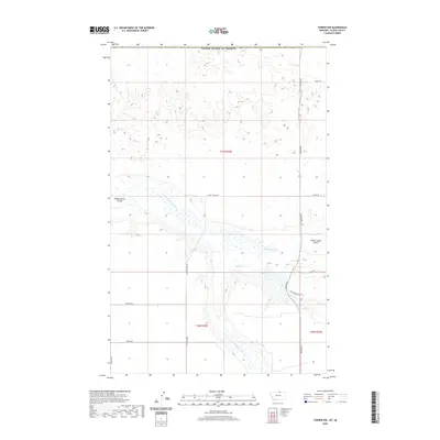
2020 Map of Turner NW
USGS Topo · Published 2020About this map
Woody Island Coulee cuts a distinct path through this northern Montana landscape, where the seasonal drainage patterns of Woody Island Cr and Buckley Cr define the local topography. This 2020 survey of Blaine County captures a sparse, agricultural grid layout just south of the international border with the United States of America. The map's road network, including Homestead Rd and Mutton Hollow Ln, reflects the large-scale ranching and farming operations that characterize the region. Local routes like Warren Rd and Swenson Rd provide access to the vast townships of t37n r25e and t36n r25e, showing how the land has been partitioned for modern use while remaining tied to the natural coulees and creek beds that have influenced movement here for generations.
Find a feature on this map
17 named features on this map. Tap any name to fly to it.
Don’t see what you’re looking for? This feature index may not catch every label — zoom into the map to look around manually.
Map Details
Editions of this 2020 Turner NW Map
This is the sole edition of this map. No revisions or reprints were ever made.
Other maps of this area

1913 · Cherry Ridge
USGS Topo · 1:125,000

1920 · Avery
USGS Topo · 1:125,000

1953 · Havre
USGS Topo · 1:250,000

1957 · Havre
USGS Topo · 1:250,000

1958 · Havre
USGS Topo · 1:250,000

1984 · Hogeland SE
USGS Topo · 1:24,000

1984 · Turner
USGS Topo · 1:24,000

1984 · Turner NE
USGS Topo · 1:24,000
1984 · Turner NW
USGS Topo · 1:24,000
1984 · Mosquito Springs
USGS Topo · 1:24,000