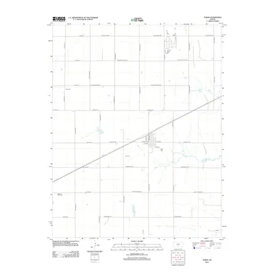
2012 Map of Turon
USGS Topo · Published 2012About this map
Agricultural patterns and a grid of rural roads define this area of Reno County, centered on the community of Turon. The town's layout is clearly visible, anchored by a central Po and a network of streets including Will St, N Burns St, and 1st Ave. This landscape is primarily shaped by its hydrology and cemeteries, serving as quiet landmarks for local genealogy and history. Waterways like Wolf Cr and Silver Cr snake through the terrain, while the Turin Cem lies just west of the main settlement. Further afield, Neola Cem and Pleasant Valley Cem sit along the section roads, indicating the scattered rural population centers that rely on thoroughfares such as W Sun City Rd and W Pretty Prairie Rd for regional connectivity.
Find a feature on this map
38 named features on this map. Tap any name to fly to it.
Don’t see what you’re looking for? This feature index may not catch every label — zoom into the map to look around manually.
Map Details
Editions of this 2012 Turon Map
This is the sole edition of this map. No revisions or reprints were ever made.
Other maps of this area

1892 · Kingman
USGS Topo · 1:125,000

1892 · Pratt
USGS Topo · 1:125,000

1894 · Kingman
USGS Topo · 1:125,000

1894 · Pratt
USGS Topo · 1:125,000

1955 · Pratt
USGS Topo · 1:250,000

1959 · Pratt
USGS Topo · 1:250,000

1966 · Cunningham
USGS Topo · 1:24,000

1967 · Penalosa
USGS Topo · 1:24,000

1967 · Cairo
USGS Topo · 1:24,000
1971 · Turon
USGS Topo · 1:24,000