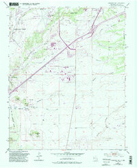
1952 Map of Turquoise Hill
USGS Topo · Published 1993About this map
Turquoise Hill and the surrounding high desert terrain south of Santa Fe reveal a landscape defined by ranching grants and early mining efforts. In this mid-century survey, updated with 1990s data, the industrial and civic expansion of the area is evident, from the Santa Fe County Municipal Airport in the north to the New Mexico State Penitentiary and the National Guard Armory. Mining heritage is preserved in labels for the Marshal Bonanza Mine (Site) and various gravel and cinder pits scattered through the Cerrillos Hills. Water management is central to life here, marked by an Aqueduct, Flume, and several drainages like Arroyo de los Chamisos and Cienega Creek. The presence of the Pacheco Grant and Cieneguilla Grant reflects the region's historical land tenure system, while newer developments like The Downs at Santa Fe show the transition toward modern recreation.
Find a feature on this map
49 named features on this map. Tap any name to fly to it.
Don’t see what you’re looking for? This feature index may not catch every label — zoom into the map to look around manually.
Map Details
Editions of this 1952 Turquoise Hill Map
3 editions found
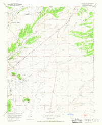
Other maps of this area

1889 · Santa Fe
USGS Topo · 1:125,000

1892 · San Pedro
USGS Topo · 1:125,000

1892 · Santa Clara
USGS Topo · 1:125,000

1894 · Santa Fe
USGS Topo · 1:125,000

1894 · Lamy
USGS Topo · 1:125,000

1951 · Agua Fria
USGS Topo · 1:24,000

1951 · Turquoise Hill
USGS Topo · 1:24,000

1952 · Santa Fe
USGS Topo · 1:24,000

1952 · Turquoise Hill
USGS Topo · 1:24,000

1952 · Seton Village
USGS Topo · 1:24,000