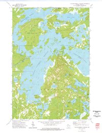
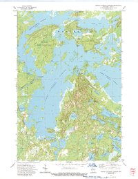
1973 Map of Turtle-Flambeau Flowage
USGS Topo · Published 1976About this map
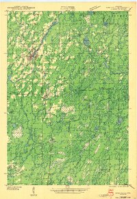
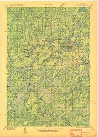
Turtle-Flambeau Flowage dominates this northern Wisconsin landscape, created by the Turtle Dam where the Flambeau River once flowed more freely. The 1973 survey reveals a complex of interconnected waters including Trude Lake, Island Lake, and French Lake. On land, the map highlights significant conservation efforts through the Big Island State Wildlife Area and Hay Creek-Hoffman Lake State Wildlife Area, protecting large tracts of land such as Big Island. The small settlement of Springstead is visible in the southeast, positioned near the Springstead Lookout Tower and Townhall. This area is characterized by its transition from a river-based system to a vast managed flowage, with numerous public access points like Fishermans Landing and several campgrounds serving the region's recreational needs during the early 1970s.
Find a feature on this map
43 named features on this map. Tap any name to fly to it.
Don’t see what you’re looking for? This feature index may not catch every label — zoom into the map to look around manually.
Map Details
Editions of this 1973 Turtle-Flambeau Flowage Map
2 editions found
Other maps of this area

1940 · Mercer
USGS Topo · 1:48,000
1940 · Butternut
USGS Topo · 1:48,000
1941 · Park Falls
USGS Topo · 1:48,000

1941 · Pike Lake
USGS Topo · 1:48,000

1942 · Pike Lake
USGS Topo · 1:48,000
1943 · Park Falls
USGS Topo · 1:48,000
1945 · Mercer
USGS Topo · 1:48,000
1947 · Park Falls
USGS Topo · 1:48,000
1947 · Butternut
USGS Topo · 1:48,000
1947 · Mercer
USGS Topo · 1:48,000