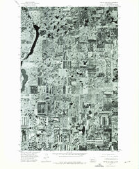
1974 Map of Turtle Lake NE
USGS Topo · Published 1975About this map
The glacial landscape of the Missouri Coteau in McLean County is captured here via aerial imagery from August 1974. The orthophotoquad is dominated by the narrow, elongated profile of Long Lake in the northwestern corner and the wider basin of Crooked Lake just to the south. This terrain is characterized by a dense network of prairie potholes and wetlands interspersed with the geometric patterns of North Dakota grain farming. The intricate textures of the fields reveal a mosaic of tillage and vegetation, showing how agricultural production has been adapted to the undulating topography of this lake-strewn region during the mid-1970s.
Find a feature on this map
2 named features on this map. Tap any name to fly to it.
Don’t see what you’re looking for? This feature index may not catch every label — zoom into the map to look around manually.
Map Details
Editions of this 1974 Turtle Lake NE Map
This is the sole edition of this map. No revisions or reprints were ever made.
Other maps of this area

1929 · Kongsberg
USGS Topo · 1:62,500

1929 · Balfour
USGS Topo · 1:62,500

1945 · Pelican Lake
USGS Topo · 1:62,500

1947 · Pelican Lake
USGS Topo · 1:62,500

1947 · Turtle Lake
USGS Topo · 1:62,500

1954 · McClusky
USGS Topo · 1:250,000

1958 · McClusky
USGS Topo · 1:250,000

1958 · Butte
USGS Topo · 1:24,000

1958 · Balfour
USGS Topo · 1:62,500

1961 · Turtle Lake
USGS Topo · 1:24,000