
1958 Map of Butte
USGS Topo · Published 1959About this map
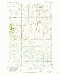
Butte serves as the primary hub of this North Dakota landscape, situated along the Minneapolis St Paul and Sault Ste Marie railroad line. The settlement pattern is defined by its proximity to this transportation artery, with the town grid positioned just north of the tracks. The topography is dominated by the prominent rise of Dogden Butte to the west, overlooking a terrain dotted with small water bodies and the expansive Cottonwood Lake to the north. A portion of the lake is designated as a National Wildlife Refuge, highlighting early conservation efforts in the region. Local educational and industrial needs are evidenced by the presence of School No 4 and various Gravel Pits, while the Soo Line reinforces the area's historical reliance on rail for moving agricultural goods and resources across the McLean and McHenry county borders.
Find a feature on this map
18 named features on this map. Tap any name to fly to it.
Don’t see what you’re looking for? This feature index may not catch every label — zoom into the map to look around manually.
Map Details
Editions of this 1958 Butte Map
2 editions found
Other maps of this area

1929 · Kongsberg
USGS Topo · 1:62,500

1929 · Balfour
USGS Topo · 1:62,500

1945 · Pelican Lake
USGS Topo · 1:62,500

1947 · Pelican Lake
USGS Topo · 1:62,500

1947 · Turtle Lake
USGS Topo · 1:62,500

1954 · McClusky
USGS Topo · 1:250,000

1958 · McClusky
USGS Topo · 1:250,000
1958 · Kongsberg NE
USGS Topo · 1:24,000
1958 · Balfour NW
USGS Topo · 1:24,000

1958 · Balfour
USGS Topo · 1:62,500