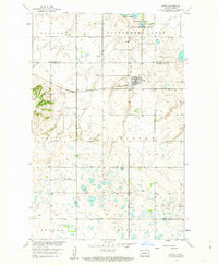
1958 Map of Butte
USGS Topo · Published 1963About this map
The town of Butte serves as the central hub of this mid-century survey, situated at the intersection of a grid-iron street plan and the Minneapolis St Paul and Sault Ste Marie rail line. The surrounding landscape in McLean County is defined by a dense concentration of small glacial potholes and wetlands, punctuated by the prominent elevation of Dogden Butte in the west. This terrain character is reflected in the establishment of the Cottonwood Lake National Wildlife Refuge in the northeast, protecting the waters of Cottonwood Lake. Land use patterns are further established by civil townships like Olivia, Aurena, and Byersville, with rural infrastructure evidenced by School No 4 and local Gravel Pits. The map captures the Missouri River Basin development era, showing a transition between concentrated town life and a highly fragmented prairie wetland environment.
Find a feature on this map
15 named features on this map. Tap any name to fly to it.
Don’t see what you’re looking for? This feature index may not catch every label — zoom into the map to look around manually.
Map Details
Editions of this 1958 Butte Map
2 editions found
Other maps of this area

1929 · Kongsberg
USGS Topo · 1:62,500

1929 · Balfour
USGS Topo · 1:62,500

1945 · Pelican Lake
USGS Topo · 1:62,500

1947 · Pelican Lake
USGS Topo · 1:62,500

1947 · Turtle Lake
USGS Topo · 1:62,500

1954 · McClusky
USGS Topo · 1:250,000

1958 · McClusky
USGS Topo · 1:250,000

1958 · Butte
USGS Topo · 1:24,000
1958 · Kongsberg NE
USGS Topo · 1:24,000
1958 · Balfour NW
USGS Topo · 1:24,000