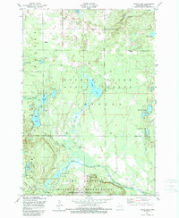
1950 Map of Turtle Lake
USGS Topo · Published 1989About this map
The Camp Grayling Military Reservation dominates the southern landscape of this mid-century survey, its boundary cutting across the winding course of the North Branch Au Sable River. This northern Michigan terrain is defined by a dense concentration of glacial lakes and wetlands, including the central Turtle Lake and the prominent Opal Lake to the west. The presence of several private landings and ranches, such as Whites Landing, Farrar Landing, and the Triple K Ranch, suggests a region deeply integrated with seasonal recreation and sporting traditions. Beyond the military grounds, much of the area is protected as part of the Pigeon River State Forest. Traces of earlier transit routes are visible in the path of the Old State Road, while several ruins and a Range Line Dam offer specific points of interest for local historians studying the area's development before 1950.
Find a feature on this map
41 named features on this map. Tap any name to fly to it.
Don’t see what you’re looking for? This feature index may not catch every label — zoom into the map to look around manually.
Map Details
Editions of this 1950 Turtle Lake Map
2 editions found
Other maps of this area

1949 · Lewiston
USGS Topo · 1:62,500

1949 · Otsego Lake
USGS Topo · 1:62,500

1950 · Johannesburg
USGS Topo · 1:24,000

1950 · Lovells
USGS Topo · 1:24,000

1950 · Turtle Lake
USGS Topo · 1:24,000

1951 · K P Lake
USGS Topo · 1:24,000

1951 · Big Bradford Lake
USGS Topo · 1:24,000

1951 · Lovells
USGS Topo · 1:24,000

1951 · Turtle Lake
USGS Topo · 1:24,000

1951 · Otsego Lake
USGS Topo · 1:24,000