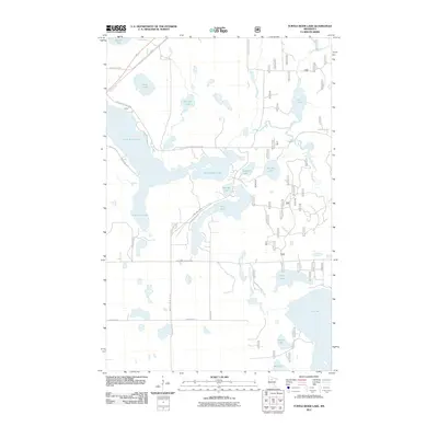
2011 Map of Turtle River Lake
USGS Topo · Published 2011About this map
Turtle River Lake and its intricate network of surrounding basins define this portion of Beltrami County, where the glacial landscape is etched with permanent water bodies and wetland corridors. The small settlement of Farley sits along the Turtle River Lake Rd NE, serving as a localized point of development amidst a geography dominated by Big Lake, Gull Lake, and the winding Turtle River. The map reveals a transition in land use, from the residential clusters along Long Lake Dr NE and Birchmont Beach Rd NE to the more utilitarian forest access routes like Forest Rte 2281 and the Blue Ox Trl. The presence of numerous smaller basins such as Flora Lake, Jessie Lake, and Gallager Lake suggests a complex drainage system that has historically influenced road placement and property boundaries in this northern Minnesota lake country.
Find a feature on this map
70 named features on this map. Tap any name to fly to it.
Don’t see what you’re looking for? This feature index may not catch every label — zoom into the map to look around manually.
Map Details
Editions of this 2011 Turtle River Lake Map
This is the sole edition of this map. No revisions or reprints were ever made.
Other maps of this area

1920 · Buena Vista
USGS Topo · 1:62,500

1954 · Bemidji
USGS Topo · 1:250,000

1957 · Bemidji
USGS Topo · 1:250,000

1958 · Bemidji
USGS Topo · 1:250,000

1968 · Bemidji East
USGS Topo · 1:24,000
1972 · Blackduck
USGS Topo · 1:24,000

1972 · Turtle River Lake
USGS Topo · 1:24,000
1972 · Pimushe Lake
USGS Topo · 1:24,000

1972 · White Fish Lake
USGS Topo · 1:24,000
1972 · Turtle River
USGS Topo · 1:24,000