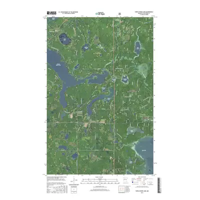
2016 Map of Turtle River Lake
USGS Topo · Published 2016About this map
Chippewa National Forest land dominates the eastern half of this northern Minnesota landscape, where a dense network of lakes and waterways defines the local geography. The winding Turtle River and Gull River connect numerous bodies of water, including the prominent Turtle River Lake and Gull Lake. This area of Beltrami County is characterized by its glacial hydrology, with smaller basins like Roadside Lake, Meadow Lake, and Flora Lake interspersed among forest tracts. A modern infrastructure of county roads and residential lanes, such as Birchmont Beach Rd NE and Turtle River Lake Rd NE, provides access to the shorelines of Big Lake and Long Lake. The map reveals a transition from the protected forest boundaries to developed lakefront properties, illustrating the contemporary layout of this recreational and wilderness region north of Bemidji.
Find a feature on this map
50 named features on this map. Tap any name to fly to it.
Don’t see what you’re looking for? This feature index may not catch every label — zoom into the map to look around manually.
Map Details
Editions of this 2016 Turtle River Lake Map
This is the sole edition of this map. No revisions or reprints were ever made.
Other maps of this area
1920 · Buena Vista
USGS Topo · 1:62,500

1954 · Bemidji
USGS Topo · 1:250,000

1957 · Bemidji
USGS Topo · 1:250,000

1958 · Bemidji
USGS Topo · 1:250,000
1968 · Bemidji East
USGS Topo · 1:24,000
1972 · Blackduck
USGS Topo · 1:24,000
1972 · Turtle River Lake
USGS Topo · 1:24,000
1972 · Pimushe Lake
USGS Topo · 1:24,000
1972 · White Fish Lake
USGS Topo · 1:24,000
1972 · Turtle River
USGS Topo · 1:24,000