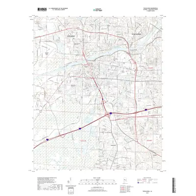
2018 Map of Tuscaloosa
USGS Topo · Published 2018About this map
Tuscaloosa and Northport flank the banks of William Bacon Oliver Lake and Warrior Lake in this 2018 survey. The map details a dense educational and civic landscape, anchored by the expansive grounds of The Univ of Alabama and Stillman College. Transportation networks converge at the Hugh R Thomas Bridge and Woolsey Finnell Bridge, which link the residential neighborhoods and hills like Childress Hill and River Hill to the commercial centers. Numerous burial grounds, including Evergreen Cem, Greenwood Cem, and Memory Hill Gardens, provide significant genealogical touchpoints across the urban and suburban transition. To the south, the terrain shifts toward more open areas near Taylorville and Stokes, where winding watercourses such as Cypress Cr and Cribbs Mill Cr define the drainage patterns. This edition captures the city's modern footprint, from the industrial activity at Tuscaloosa Regional Airport to the quiet reaches of Moodys Swamp.
Find a feature on this map
71 named features on this map. Tap any name to fly to it.
Don’t see what you’re looking for? This feature index may not catch every label — zoom into the map to look around manually.
Map Details
Editions of this 2018 Tuscaloosa Map
This is the sole edition of this map. No revisions or reprints were ever made.
Other maps of this area

1899 · Brookwood
USGS Topo · 1:125,000

1924 · Tuscaloosa
USGS Topo · 1:62,500

1926 · Samantha
USGS Topo · 1:48,000

1926 · Tuscaloosa
USGS Topo · 1:62,500

1928 · Samantha
USGS Topo · 1:62,500

1929 · Searles
USGS Topo · 1:48,000

1931 · Cottondale
USGS Topo · 1:48,000

1934 · Searles
USGS Topo · 1:62,500

1934 · Cottondale
USGS Topo · 1:62,500

1953 · Birmingham
USGS Topo · 1:250,000