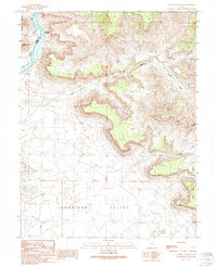
1991 Map of Tusher Canyon
USGS Topo · Published 1991About this map
The Green River carves a deep course through this high desert landscape, marking the border between Emery Co and Grand Co in the early 1990s. The terrain is defined by dramatic vertical relief, from the heights of the Beckwith Plateau and Suluar Mesa down to the sweeping Gunnison Valley. Water remains the most critical resource in this arid expanse, evidenced by isolated Water Tanks and the complex drainage systems of Tusher Wash and Tusher Canyon.
Find a feature on this map
19 named features on this map. Tap any name to fly to it.
Don’t see what you’re looking for? This feature index may not catch every label — zoom into the map to look around manually.
Map Details
Editions of this 1991 Tusher Canyon Map
This is the sole edition of this map. No revisions or reprints were ever made.
Other maps of this area

1885 · San Rafael
USGS Topo · 1:250,000

1885 · East Tavaputs
USGS Topo · 1:250,000

1885 · La Sal
USGS Topo · 1:250,000

1886 · Price River
USGS Topo · 1:250,000

1896 · Price River
USGS Topo · 1:250,000

1954 · Tidwell 1 NE
USGS Topo · 1:24,000

1954 · Tidwell 1 NW
USGS Topo · 1:24,000

1954 · Green River
USGS Topo · 1:62,500

1956 · Salina
USGS Topo · 1:250,000

1956 · Price
USGS Topo · 1:250,000