2001 Map of Twain Harte
USGS Topo · Published 2004About this map
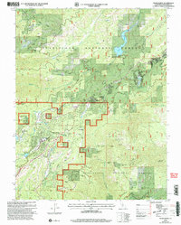
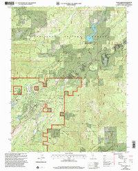
Stanislaus National Forest serves as the dominant backdrop for this high-elevation landscape, where timber and mining legacies intersect with mid-century residential developments. The area's industrial history is marked by the Hess Mill (Site) and a dense concentration of quartz and gold prospects, including the Confidence Mine, Lucky Strike Mine, and the Ryan Mine. These workings are scattered across the drainages of the South Fork Stanislaus River and the North Fork Tuolumne River.
Find a feature on this map
56 named features on this map. Tap any name to fly to it.
Don’t see what you’re looking for? This feature index may not catch every label — zoom into the map to look around manually.
Map Details
Editions of this 2001 Twain Harte Map
2 editions found
Other maps of this area

1891 · Big Trees
USGS Topo · 1:125,000

1893 · Sonora
USGS Topo · 1:125,000

1894 · Big Trees
USGS Topo · 1:125,000

1896 · Sonora
USGS Topo · 1:125,000

1897 · Sonora
USGS Topo · 1:125,000

1897 · Big Trees
USGS Topo · 1:125,000

1898 · Sonora
USGS Topo · 1:125,000

1901 · Big Trees
USGS Topo · 1:125,000

1947 · Sacramento
USGS Topo · 1:250,000

1947 · San Jose
USGS Topo · 1:250,000