2001 Map of Twain Harte
USGS Topo · Published 2004About this map
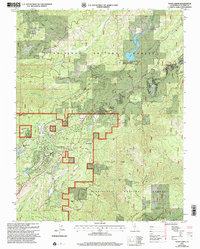
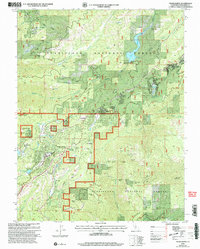
Twain Harte and the surrounding timberlands of the Stanislaus National Forest define this 2001 revision, which captures the Sierra Nevada foothills at the start of the new millennium. The landscape is a complex overlay of historic resource extraction and modern mountain recreation, marked by the proximity of high-elevation communities like Sierra Village and Mi-Wuk Village along the highway corridor. Evidence of the region's hard-rock mining legacy is scattered across the terrain, with sites such as the Confidence Mine, Stanislaus Mine, and Red Cloud Mine providing critical spatial data for industrial historians and researchers.
Find a feature on this map
54 named features on this map. Tap any name to fly to it.
Don’t see what you’re looking for? This feature index may not catch every label — zoom into the map to look around manually.
Map Details
Editions of this 2001 Twain Harte Map
2 editions found
Other maps of this area

1891 · Big Trees
USGS Topo · 1:125,000

1893 · Sonora
USGS Topo · 1:125,000

1894 · Big Trees
USGS Topo · 1:125,000

1896 · Sonora
USGS Topo · 1:125,000

1897 · Sonora
USGS Topo · 1:125,000

1897 · Big Trees
USGS Topo · 1:125,000

1898 · Sonora
USGS Topo · 1:125,000

1901 · Big Trees
USGS Topo · 1:125,000

1947 · Sacramento
USGS Topo · 1:250,000

1947 · San Jose
USGS Topo · 1:250,000