
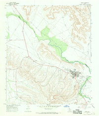
1967 Map of Twelvemile Camp
USGS Topo · Published 1970About this map
Twelvemile Camp sits at the northern edge of this high-desert plateau, where the landscape is defined by deep incisions from Twelvemile Creek and the Pecos R along the western boundary. This 1967 field-checked survey reveals an economy deeply tied to resource extraction and cattle ranching in Crockett and Pecos counties. Numerous Drill Holes, Oil Wells, and a Gas Well dot the terrain, linked by an extensive Pipeline network that cuts across the contours. The presence of a Gravel Pit and a isolated Corral underscores the dual nature of land use here, while Simpson Canyon and Deer Canyon provide significant topographical relief. Small, functional landmarks like a Water Tank and the locality of Archer serve as vital navigation points in this arid, industrializing West Texas environment.
Find a feature on this map
15 named features on this map. Tap any name to fly to it.
Don’t see what you’re looking for? This feature index may not catch every label — zoom into the map to look around manually.
Map Details
Editions of this 1967 Twelvemile Camp Map
This is the sole edition of this map. No revisions or reprints were ever made.
Other maps of this area

1928 · Rankin
USGS Topo · 1:125,000

1929 · Sheffield
USGS Topo · 1:125,000

1954 · Sonora
USGS Topo · 1:250,000

1954 · San Angelo
USGS Topo · 1:250,000

1958 · Sonora
USGS Topo · 1:250,000

1958 · San Angelo
USGS Topo · 1:250,000

1965 · San Angelo
USGS Topo · 1:250,000

1967 · Divide Country
USGS Topo · 1:24,000

1967 · Deer Canyon
USGS Topo · 1:24,000
1967 · Iraan
USGS Topo · 1:24,000