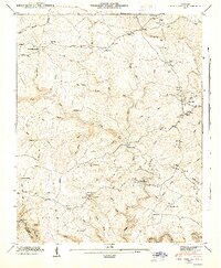
1945 Map of Twin Bridges
USGS Topo · Published 1946About this map
Deer Lodge Academy and the village of Deer Lodge anchor the eastern plateau in this mid-1940s survey of the Tennessee Valley Divide. The landscape is defined by a dense network of headwater streams including Alexander Creek, Witt Creek, and White Creek, which carve deep drainage patterns through the Cumberland Plateau. Human settlement is traced through isolated country institutions like Pleasant Green Ch, Englewood Sch, and Flat Rock Sch. Economic activity is evidenced by Adkins Mill on Muddy Br, while local transport relies on traditional crossings such as White Ford and the Lavender Bridge. The map captures a transition where the high ground of the Divide separates the Tennessee Valley drainage from the rugged creek beds of the south, marked by family-named landmarks like the Branstetter Cem and Myers Cem.
Find a feature on this map
108 named features on this map. Tap any name to fly to it.
Don’t see what you’re looking for? This feature index may not catch every label — zoom into the map to look around manually.
Map Details
Editions of this 1945 Twin Bridges Map
This is the sole edition of this map. No revisions or reprints were ever made.
Other maps of this area

1895 · Wartburg
USGS Topo · 1:125,000

1896 · Wartburg
USGS Topo · 1:125,000

1935 · Lancing
USGS Topo · 1:24,000

1935 · Pilot Mountain
USGS Topo · 1:24,000

1936 · Hebbertsburg
USGS Topo · 1:24,000

1936 · Fox Creek
USGS Topo · 1:24,000

1936 · Twin Bridges
USGS Topo · 1:24,000

1936 · Jones Knob
USGS Topo · 1:24,000
1943 · Hebbertsburg
USGS Topo · 1:24,000

1943 · Twin Bridges
USGS Topo · 1:24,000