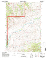
1991 Map of Twin Creek
USGS Topo · Published 1997About this map
The South Fork Shoshone River carves through this Park County landscape, defining the transition between the protected Washakie Wilderness and the industrial activity of the South Shoshone Oil Field. This survey captures the working character of the region in the early 1990s, where agricultural operations like the TE Ranch and TE Cow Camp rely on irrigation infrastructure such as the Lakeview Ditch. The rugged topography is anchored by the massive Carter Mountain to the southeast, while numerous watercourses like Houlihan Creek, Ishawooa Creek, and Jordan Creek drain the surrounding Shoshone National Forest. This map offers a clear view of the balance between resource extraction, ranching heritage, and wilderness preservation, providing a detailed record of land use and property boundaries along the river's winding path.
Find a feature on this map
33 named features on this map. Tap any name to fly to it.
Don’t see what you’re looking for? This feature index may not catch every label — zoom into the map to look around manually.
Map Details
Editions of this 1991 Twin Creek Map
This is the sole edition of this map. No revisions or reprints were ever made.
Other maps of this area

1893 · Ishawooa
USGS Topo · 1:125,000

1895 · Ishawooa
USGS Topo · 1:125,000

1899 · Ishawooa
USGS Topo · 1:125,000

1955 · Cody
USGS Topo · 1:250,000

1957 · Wapiti
USGS Topo · 1:62,500

1957 · Irish Rock
USGS Topo · 1:62,500

1958 · Cody
USGS Topo · 1:250,000

1962 · Cody
USGS Topo · 1:250,000
1970 · Ptarmigan Mountain
USGS Topo · 1:24,000
1970 · Flag Peak
USGS Topo · 1:24,000