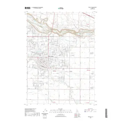
2020 Map of Twin Falls
USGS Topo · Published 2020About this map
The Snake River carves a deep, dramatic path across this northern Idaho landscape, defining the boundary between Jerome and Twin Falls counties. This 2020 map documents the urban development of Twin Falls as it expands toward the canyon rim, connected to the north by the iconic Perrine Memorial Bridge. The landscape is a study in hydrological engineering and natural wonders, where the agricultural lifeblood of the Low Line Canal and the Orchalara Seepage Tunnel exists alongside the massive cataracts of Shoshone Falls and Perrine Coulee Falls. Within the city grid, researchers can locate significant civic landmarks like the Theron W Ward Judicial Building and the College of Southern Idaho. Further east, the smaller settlements of McMillan and Kimberly anchor the surrounding rural tracts, while recreation areas like Blue Lakes and Dierkes Lake highlight the unique geology of the canyon floor.
Find a feature on this map
132 named features on this map. Tap any name to fly to it.
Don’t see what you’re looking for? This feature index may not catch every label — zoom into the map to look around manually.
Map Details
Editions of this 2020 Twin Falls Map
This is the sole edition of this map. No revisions or reprints were ever made.
Other maps of this area

1950 · Filer
USGS Topo · 1:24,000

1950 · Jerome
USGS Topo · 1:24,000

1950 · Jerome
USGS Topo · 1:62,500

1955 · Twin Falls
USGS Topo · 1:250,000

1958 · Twin Falls
USGS Topo · 1:250,000

1964 · Kimberly
USGS Topo · 1:24,000

1964 · Falls City
USGS Topo · 1:24,000

1964 · Twin Falls
USGS Topo · 1:24,000

1964 · Perrine
USGS Topo · 1:24,000

1965 · Stricker Butte
USGS Topo · 1:24,000