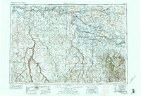
1955 Map of Twin Falls
USGS Topo · Published 1974About this map
The Snake River carves a deep path across this mid-century landscape, anchoring a network of irrigation and infrastructure essential to the Magic Valley's growth. The northern agricultural plains, dotted with settlements like Jerome, Buhl, and Twin Falls, contrast sharply with the expansive desert and lava beds to the south. This survey highlights the region's mid-century development, showing the Union Pacific railroad lines connecting cattle and produce hubs, while remote outposts like Wickahoney and Grasmere sit along the southwestern plateaus. Significant water management is evident through the C.J. Strike Reservoir and Wilson Lake Reservoir. To the west, the Saylor Creek Air Force Range occupies a vast tract of the high desert, while the northern edge is defined by the volcanic topography of Lava flows and the timbered slopes of the Sawtooth National Forest.
Find a feature on this map
73 named features on this map. Tap any name to fly to it.
Don’t see what you’re looking for? This feature index may not catch every label — zoom into the map to look around manually.
Map Details
Editions of this 1955 Twin Falls Map
3 editions found

Other maps of this area

1892 · Mountain Home
USGS Topo · 1:125,000

1892 · Bisuka
USGS Topo · 1:125,000

1892 · Camas Prairie
USGS Topo · 1:125,000

1893 · Mountain Home
USGS Topo · 1:125,000

1893 · Camas Prairie
USGS Topo · 1:125,000

1894 · Bisuka
USGS Topo · 1:125,000

1936 · Mountain City
USGS Topo · 1:62,500

1936 · Rowland
USGS Topo · 1:48,000

1939 · Owyhee
USGS Topo · 1:62,500

1940 · Rowland
USGS Topo · 1:62,500