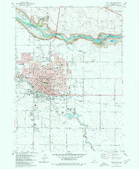
1979 Map of Twin Falls
USGS Topo · Published 1980About this map
The Snake River carves a dramatic northern boundary for this urban and agricultural landscape, marked by the iconic drops at Shoshone Falls and Pillar Falls. The city of Twin Falls dominates the central map area, showing a well-established mid-century grid with numerous institutional landmarks such as the College of Southern Idaho and Robert Stuart Jr High Sch. The town's industrial and agricultural base is evident through the presence of a Sugar Factory and its associated Industrial Waste Ponds, as well as the Union Pacific railroad line that cuts through the heart of the community.
Find a feature on this map
67 named features on this map. Tap any name to fly to it.
Don’t see what you’re looking for? This feature index may not catch every label — zoom into the map to look around manually.
Map Details
Editions of this 1979 Twin Falls Map
This is the sole edition of this map. No revisions or reprints were ever made.
Other maps of this area

1950 · Filer
USGS Topo · 1:24,000

1950 · Jerome
USGS Topo · 1:24,000

1950 · Jerome
USGS Topo · 1:62,500

1955 · Twin Falls
USGS Topo · 1:250,000

1958 · Twin Falls
USGS Topo · 1:250,000

1964 · Kimberly
USGS Topo · 1:24,000

1964 · Falls City
USGS Topo · 1:24,000

1964 · Twin Falls
USGS Topo · 1:24,000

1964 · Perrine
USGS Topo · 1:24,000

1965 · Stricker Butte
USGS Topo · 1:24,000