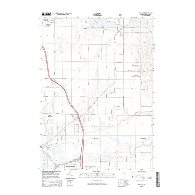
2014 Map of Twin Lake
USGS Topo · Published 2014About this map
Muskegon and its northern suburbs are defined by a complex network of waterways where the Muskegon River and its North Channel meet Muskegon Lake. This landscape shows a distinct transition from the dense urban and academic environment near Muskegon Community Coll to the managed woodlands of the Manistee National Forest in the east. The northern half of the map is punctuated by glacial lakes including North Lake, West Lake, and the namesake Twin Lakes, which serve as the centerpiece for the community of Twin Lake. A wealth of local history is recorded through small burial sites like Oakland Cem and Horton Cem, while the presence of the Midget Airport and Berry Junction highlights the region's diverse transportation and aviation infrastructure.
Find a feature on this map
72 named features on this map. Tap any name to fly to it.
Don’t see what you’re looking for? This feature index may not catch every label — zoom into the map to look around manually.
Map Details
Editions of this 2014 Twin Lake Map
This is the sole edition of this map. No revisions or reprints were ever made.
Other maps of this area

1929 · Montague
USGS Topo · 1:48,000

1930 · Lake Harbor
USGS Topo · 1:48,000

1930 · Muskegon
USGS Topo · 1:62,500

1936 · Muskegon
USGS Topo · 1:62,500

1936 · Lake Harbor
USGS Topo · 1:62,500

1954 · Milwaukee
USGS Topo · 1:250,000

1958 · Milwaukee
USGS Topo · 1:250,000

1958 · Twin Lake
USGS Topo · 1:62,500

1959 · Montague
USGS Topo · 1:62,500
1972 · Sullivan
USGS Topo · 1:24,000