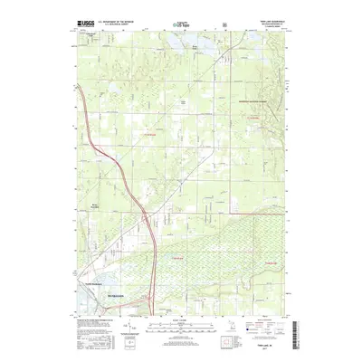
2017 Map of Twin Lake
USGS Topo · Published 2017About this map
Twin Lake and the surrounding township show a landscape defined by the transition from the Manistee National Forest in the east to the river-fed wetlands near Muskegon in the south. The area is characterized by a high concentration of small cemeteries, such as Oakland Cem, Oak Hill Cem, and Horton Cem, which anchor the rural crossroads and small settlements of Lakewood Club and Berry Junction. The Muskegon River and its North Channel create a complex system of waterways and drains, including the Brandstrom Drain and Bear Cr, which shape the local topography.
Find a feature on this map
113 named features on this map. Tap any name to fly to it.
Don’t see what you’re looking for? This feature index may not catch every label — zoom into the map to look around manually.
Map Details
Editions of this 2017 Twin Lake Map
This is the sole edition of this map. No revisions or reprints were ever made.
Other maps of this area

1929 · Montague
USGS Topo · 1:48,000

1930 · Lake Harbor
USGS Topo · 1:48,000

1930 · Muskegon
USGS Topo · 1:62,500

1936 · Muskegon
USGS Topo · 1:62,500

1936 · Lake Harbor
USGS Topo · 1:62,500

1954 · Milwaukee
USGS Topo · 1:250,000

1958 · Milwaukee
USGS Topo · 1:250,000

1958 · Twin Lake
USGS Topo · 1:62,500

1959 · Montague
USGS Topo · 1:62,500
1972 · Sullivan
USGS Topo · 1:24,000