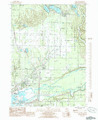
1985 Map of Twin Lake
USGS Topo · Published 1985About this map
The complex waterway network of the Muskegon River delta dominates this mid-1980s topographic portrait, showing the intricate splits into the North Channel, Middle Channel, and South Channel. These channels empty into the expansive Muskegon Lake at the southern edge of the map, adjacent to North Muskegon. The transition from the urban-adjacent college campus of Muskegon Community College and the Northside Airport to the conserved wetlands of the Muskegon State Game Area illustrates the varying land use of the period.
Find a feature on this map
53 named features on this map. Tap any name to fly to it.
Don’t see what you’re looking for? This feature index may not catch every label — zoom into the map to look around manually.
Map Details
Editions of this 1985 Twin Lake Map
This is the sole edition of this map. No revisions or reprints were ever made.
Other maps of this area

1929 · Montague
USGS Topo · 1:48,000

1930 · Lake Harbor
USGS Topo · 1:48,000

1930 · Muskegon
USGS Topo · 1:62,500

1936 · Muskegon
USGS Topo · 1:62,500

1936 · Lake Harbor
USGS Topo · 1:62,500

1954 · Milwaukee
USGS Topo · 1:250,000

1958 · Milwaukee
USGS Topo · 1:250,000

1958 · Twin Lake
USGS Topo · 1:62,500

1959 · Montague
USGS Topo · 1:62,500
1972 · Sullivan
USGS Topo · 1:24,000