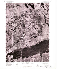
1976 Map of Twin Lake SW
USGS Topo · Published 1979About this map
The northern reaches of Muskegon and its immediate surroundings are captured in this 1976 orthophotoquad, which uses aerial photography to provide a direct look at the mid-1970s landscape. This format reveals the intricate relationship between the expanding suburban developments and the natural hydrological features of the region, specifically near Twin Lake and the northern borders of North Muskegon. The photographic imagery preserves the exact footprint of residential blocks, industrial corridors, and the wooded fringes of Lakewood before later decades of development further altered the area. Unlike traditional topographic maps, this record highlights the density of forest cover and the precise layout of local road networks that connected these lakeside communities during a period of steady growth along the Michigan shoreline.
Find a feature on this map
4 named features on this map. Tap any name to fly to it.
Don’t see what you’re looking for? This feature index may not catch every label — zoom into the map to look around manually.
Map Details
Editions of this 1976 Twin Lake SW Map
This is the sole edition of this map. No revisions or reprints were ever made.
Other maps of this area

1929 · Montague
USGS Topo · 1:48,000

1930 · Lake Harbor
USGS Topo · 1:48,000

1930 · Muskegon
USGS Topo · 1:62,500

1936 · Muskegon
USGS Topo · 1:62,500

1936 · Lake Harbor
USGS Topo · 1:62,500

1954 · Milwaukee
USGS Topo · 1:250,000

1958 · Milwaukee
USGS Topo · 1:250,000

1958 · Twin Lake
USGS Topo · 1:62,500

1959 · Montague
USGS Topo · 1:62,500
1972 · Sullivan
USGS Topo · 1:24,000